

A cost-effective approach to incorporate landscape connectivity in Environmental Impact Assessments
Written by Evi A.D. Paemelaere
July 26th, 2023
Environmental Impact Assessments need to shift from local to landscape level impacts
Road networks develop at a rapid pace, many giving direct access to intact habitats previously protected only by their inaccessibility. Environmental Impact Assessments (EIAs) are a powerful tool in identifying and mitigating impacts from roads on wildlife and their habitat because they can standardise approaches and promote science-based best practices.
Often, however, they are limited by time and financial resources to gather solid data to inform the decision-making process. Moreover, EIAs tend to focus on localized impacts, rather than considering landscape level effects. Landscape connectivity is key to the survival of wildlife, but is often not adequately considered in EIAs, which needs to change.

Figure 1 - Flow chart of the proposed framework. (Click to open as Pdf)
Engineering and environmental needs can go hand in hand for pro-active mitigation.
We proposed a multi-species, landscape-level prioritization framework (Figure 1) for pro-active mitigation strategies that integrate engineering and environmental needs and offered an example from a case study in Guyana where a currently unpaved road crossing through tropical forests, savannas, and wetlands within Indigenous titled lands will be upgraded (Figure 2).

Figure 2 - Landscape and road from the case study in Guyana
Whether the existing road in the Guyana example is upgraded or a new road is built, bridges and culverts are required for drainage. If well-designed, these structures can serve as wildlife underpasses because many species are associated with waterways. Wildlife friendly design can also improve the life of the structures by avoiding damage from erosion and accumulation of debris, and it helps maintain water flow and quality for aquatic species.
Considering the location and design of these structures from the get-go can help limit the need for additional, more costly mitigation measures post-construction.
A multi-species approach in the prioritization and underpass design process
In EIAs it is not possible to consider all species. We proposed a prioritization method based on a species:
conservation status
cultural importance
response to roads and traffic (no response, freeze (pauser) flight (speeder) or avoider
characteristics of the crossing structure it will use (e.g., bridge, culvert, etc.) (Figure 3).
The categories are based on species’ response to danger and their habitat requirements. Including species from each of the different categories of these frameworks ensured that our selected species not only included those sensitive to human development but also representatives of other species’ needs in this mitigation approach.
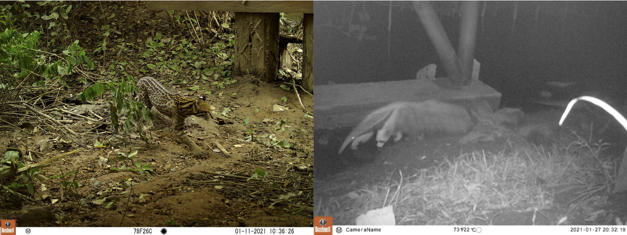
Figure 3 - The ocelot (left) is a “speeder”, most likely to become roadkill with high traffic volume and/or speed. The giant anteater (right) is a “non-responder”, an easy victim to road kill even with low traffic volume or speed. Both are “structural generalists”: as long as the bridge is within their movement paths and high enough to easily pass under, they will use it.
Focusing resources on landscape-level planning rather than on limited local but expensive field work
Many EIAs undertake general surveys which generate vast species lists and standard recommendations. However, such surveys are often insufficient to detect rare or endemic species and targeted surveys, including at larger spatial scales, should be considered.
Rather, with the support of spatial analysts, landscape-level approaches can be incorporated through freely available maps of habitat and geographic characteristics. The variables considered depend on the species. In our case study in Guyana, we used forest cover, distance to forest, water, villages, roads and topography. The strength of this approach lies in the ability to include existing features and those that are planned, such as the proposed alignment of a road and associated predicted deforestation.
Connectivity models without new field data
In most cases, few species have been intensively studied locally to inform the EIA. Nevertheless, literature on the species in similar habitats is often available to produce resistance values for an expert-based connectivity model. This model uses the species’ resistance to movement and considers all potential pathways across the landscape.
The model considers the relative importance of each landscape variable for specific species and how easy or difficult it would be for them to move through an area with such characteristics. Our paper showed that experts on these species, with the support of the literature, can make good predictions of the role of spatial variables on species movements through the landscape.
The maps can then be combined into a multi-species map highlighting important habitat and connectivity areas, as well priority sites for intervention along the proposed road (Figure 4).
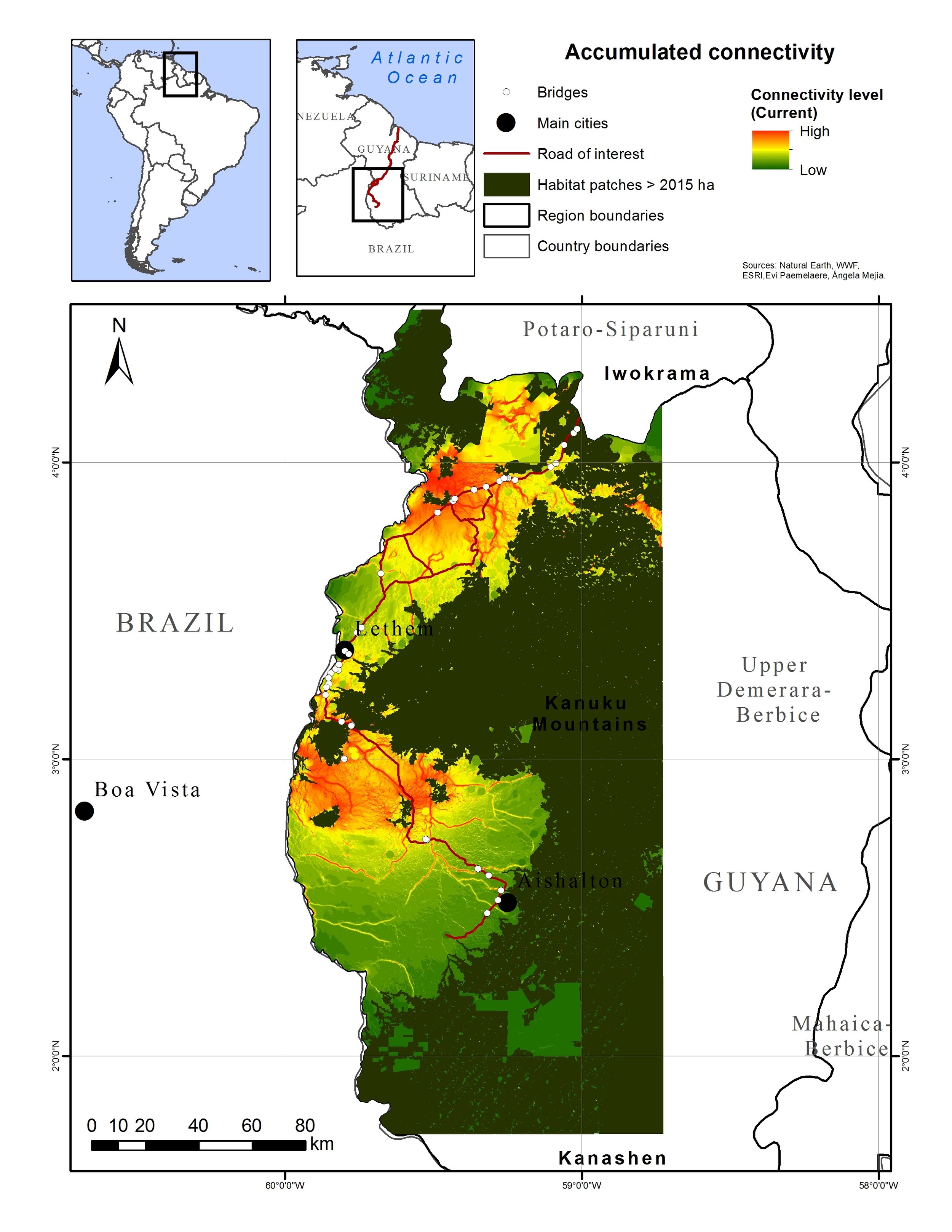
Figure 4 - The combined species connectivity model indicates important movement areas for species and their intersections with roads, where measures must be put in place to ensure their safe crossing. If bridges or culverts exist or are planned at these locations, they can be fitted to the species’ needs. If there are no structures already proposed, they can then be added.
If those intersections correspond with bridge or culvert placement, these structures can be tailored to serve the type of species expected to pass there. Where no such structures are required from an engineering perspective, pro-active measures can still be considered to help avoid more costly solutions post-construction.

Figure 5 – Bridges at priority sites are evaluated based on the structural needs of the species. Left: priority site for savannah deer crossing, where we recommended a higher and longer bridge to facilitate their movement. Right: priority site for most species in our study. It was well-built: sufficient height for all species, vegetation cover for smaller species and open field of view for others, and long enough to permit free water flow alongside dry area for terrestrial species.
Post-construction follow-up
The proposed framework focuses on wildlife movements and all potential impacts they may experience based on their behavioral response to roads and predicted locations of roadkill. Importantly, roadkill hotspots do not always correspond with connectivity hotspots and additional mitigation may be required. Post-construction roadkill data is necessary to evaluate the effectiveness of mitigation and to adapt as conditions change.
The advantage of the proposed framework and connectivity model is that it permits hypothesis testing of species use of the habitat pre-and post-development, and their use of the underpasses, strengthening the evaluation process. Lastly, post-construction management, such as roadside habitat, human activity, and fencing, are important elements in addition to the structural considerations. Our road response and crossing guild and spatial modelling framework offer guidance for locations and types of management required. Incorporating this framework into EIAs can promote proactive mitigation measures and help improve landscape connectivity for wildlife friendlier road development.
Author information
Evi A.D. Paemelaere, Angela Mejía, Simón Quintero, Matthew Hallett, Fernando Li, Asaph Wilson, Howard Barnabas, Andrew Albert, Rhomayne Li, Leon Baird, Gerard Pereira, and Jeremy Melville.
Source citation
Evi A.D. Paemelaere et al. (2023) The road towards wildlife friendlier infrastructure: Mitigation planning through landscape-level priority settings and species connectivity frameworks. Environmental Impact Assessment Review, Volume 99, 107010. https://doi.org/10.1016/j.eiar.2022.107010
Editor:
Rodney van der Ree
Cite this summary:
Paemelaere, E.A.D (2023). A cost-effective approach to incorporate landscape connectivity in Environmental Impact Assessments. Edited by van der Ree, R. TransportEcology.info, Accessed at: https://transportecology.info/research/cost-effective-landscape-connectivity-eias