

Filling knowledge gaps at the landscape level in planning roadkill mitigation measures may offer optimal cost-efficiency solutions for multiple species and taxa
Written by Francesco Valerio
Universidade de Évora, Portugal
25th May 2023
Numerous knowledge gaps need to be filled to better inform planning to prevent roadkill
Deciding where to implement mitigation structures during the planning phase of transport projects is difficult because there are many uncertainties and knowledge gaps at the landscape level.
Corridors and other movement pathways can be difficult to identify because wildlife species have varying ecological needs and mobility capacities as well as uneven distribution across landscapes. Nevertheless, this is a challenge that deserves more attention in ecological impact assessments. Landscape connectivity needs to be addressed less superficially and simultaneously include multiple species and mitigation should be effective for multiple taxa.
It is essential to distinguish the landscape factors affecting roadkill that are associated with habitats from those that are associated with landscape connectivity, since the former are widely recognized, though the second are usually overlooked, especially when considering that road-related mortality may also occur outside habitats along connectivity corridors (e.g., during dispersal).
Four typically overlooked aspects should be addressed to increase the effectiveness of mitigation structures:
landscape dynamism (e.g. landscape changes)
securing sub-optimal sites for mitigation as alternatives whenever the best sites are unavailable
that effectiveness of mitigation structures is contextualised with respect to the entire landscape, namely considering species’ biological needs with the larger landscape and ecological context in which it is placed.
that mitigation measures and sites with mitigation measures should address multiple species.
Enhancing the spatial prioritisation of where to implement roadkill mitigation measures
Our latest research identified high-risk roadkill areas that offer the best sites for implementing mitigation structures along roads. We designed a testable strategy to address the four typically overlooked gaps to improve the spatial prioritisation and adaptability of mitigation measures. We chose 19 forest-dependent species from three taxonomic groups (non-flying animals, birds, and bats). We conducted our study in a real-world landscape in the Évora district of Portugal, using roadkill and species occurrence data collected between 2005 and 2020.
Most studies that attempt to understand the distribution of roadkill relate the number of dead animals with categorical variables that describe the road and traffic (e.g. road width, traffic volume), landscape and habitat characteristics (e.g. land cover classes) and landscape connectivity as general surrogate of multiple species (e.g. species-agnostic). We did not use categorical descriptors as they do not represent the complexity of wildlife communities, and adopted more sensitive and continuous descriptors derived from remote sensing satellite data. These variables are both highly detailed and better able to represent unique habitats, while able to account for landscape dynamics over time.
We also adopted a more detailed, species-specific landscape representation of connectivity that takes into account the many possibilities in which different wildlife populations might travel across the landscape and potentially interact with roads.
To determine the probability of roadkill, we used a combination of road, habitat metrics, and species-specific connectivity models that were tailored to each species. We verified the roadkill risk across species, as well as the differences within and amongst selected taxonomic groups.
Theoretical and practical advances for roadkill mitigation
Remote sensing represents a crucial discipline that has theoretical and practical benefits for transport ecology. Theoretically, we discovered that similar species within each taxonomic group responded to similar remotely sensed habitat metrics (Figure 1), not only in terms of wildlife distribution in the entire study area, but also mortality along roads. This was whilst offering new ecological insights related with environmental tolerance from specialist to generalist species. Practically, we found that remote sensing also provided a previously unimaginable benefit by accurately pinpointing high-risk road areas throughout a 15-year period in a changing landscape, therefore helping avoid approximations in spatial planning, as this may result in misplaced resources.
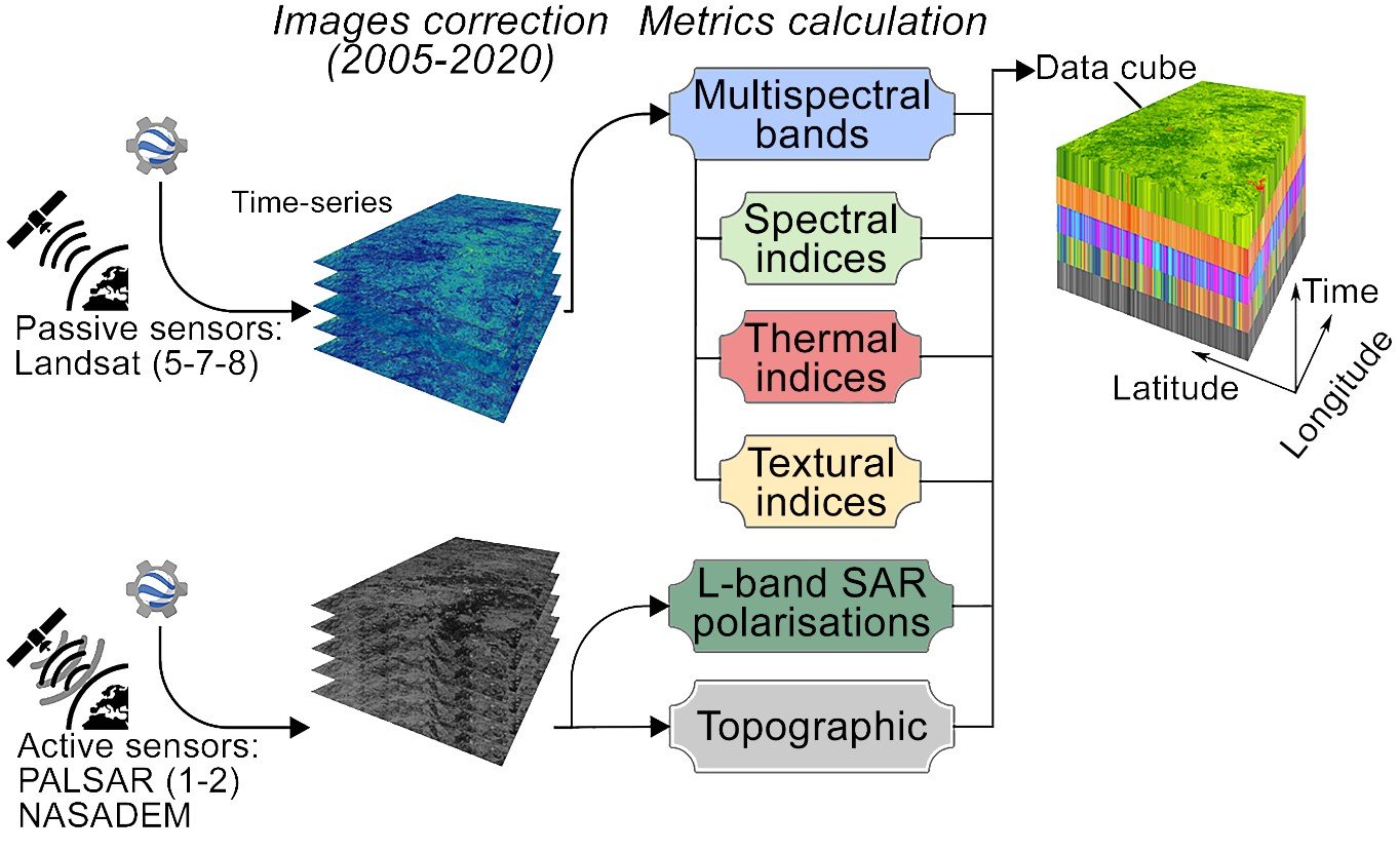
Figure 1. The framework used to collect and calculate remotely sensed habitat metrics.
We also found that the geographic locations of mortality events were explained by a combination of road descriptors, habitat metrics and landscape connectivity (including movements in non-habitat areas). This highlights the need to consider species-specific connectivity representations for an entire study area, and not only for areas identified as habitat. For example, expanding mitigation efforts (i.e., fences) along roads in typically-overlooked areas, such as farmland or residential areas, can result in greater connectivity and roadkill reductions. It is critical to understand that animals use ‘habitat’ as well as sub-optimal land-uses for movement.
We were able to find precise locations in the study area that represent multiple species and taxa in preventing road mortality. Our investigation further discovered that roadkill mitigation structures implemented to protect one taxonomic group may have unintended positive consequences for another, factoring into opportunity costs. We also confirmed that sub-optimal locations adjacent to optimal locations may still provide efficient and cost-effective solutions. This is particularly so when optimal sites are unavailable due to topographic constraints, or when convenient structures are already present, such as drainage culverts which may help to improve connectivity (Figure 2).

Figure 2. Drainage culverts adapted to incorporate a dry ledge, facilitating wildlife movements during wet periods (LIFE LINES project).
Addressing the gaps
Our research proposed significant developments accounting for several gaps in helping resource allocation and reducing the risk of inappropriately placed crossing structures. We demonstrated how planners, designers and regulators can develop prioritised and cost-effective mitigation plans that identify the best sites for mitigation structures, concomitantly with alternative sites with ‘acceptable’ uncertainty (Figure 3). This approach also maximised the financial return on investment and minimised uncertainties. This is critical when considering the elevated cost associated with mitigation structures, coupled with the scarce resources available for conservation.

Figure 3. Road planning units (RPUs) with the number of species subject to mortality risk, i.e. cumulated mortality risk (a), and frequency histograms indicating that few high-risk sites are able to better inform on mortality protection for multiple species (b). In sites that included all communities (c), the coefficient of variation (CV) of cumulated mortality risk indicates ‘acceptable’ (CV<30) uncertainty for sub-optimal sites (d). Darker areas correspond to higher cumulated mortality risk (dark violet).
Author information
Francesco Valerio - MED - Mediterranean Institute for Agriculture, Environment and Development & CHANGE – Global Change and Sustainability Institute, Instituto de Investigação e Formação Avançada, Universidade de Évora, Pólo da Mitra, Ap. 94, 7006-554, Évora, Portugal
Sérgio Godinho - EaRSLab—Earth Remote Sensing Laboratory, University of Évora, 7000-671, Évora, Portugal
Pedro Salgueiro - MED - Mediterranean Institute for Agriculture, Environment and Development & CHANGE – Global Change and Sustainability Institute, Instituto de Investigação e Formação Avançada, Universidade de Évora, Pólo da Mitra, Ap. 94, 7006-554, Évora, Portugal
Denis Medinas - MED - Mediterranean Institute for Agriculture, Environment and Development & CHANGE – Global Change and Sustainability Institute, Instituto de Investigação e Formação Avançada, Universidade de Évora, Pólo da Mitra, Ap. 94, 7006-554, Évora, Portugal
Giovanni Manghi - MED - Mediterranean Institute for Agriculture, Environment and Development & CHANGE – Global Change and Sustainability Institute, Instituto de Investigação e Formação Avançada, Universidade de Évora, Pólo da Mitra, Ap. 94, 7006-554, Évora, Portugal
António Mira - MED - Mediterranean Institute for Agriculture, Environment and Development & CHANGE – Global Change and Sustainability Institute, Instituto de Investigação e Formação Avançada, Universidade de Évora, Pólo da Mitra, Ap. 94, 7006-554, Évora, Portugal
Nuno M. Pedroso - MED - Mediterranean Institute for Agriculture, Environment and Development & CHANGE – Global Change and Sustainability Institute, Instituto de Investigação e Formação Avançada, Universidade de Évora, Pólo da Mitra, Ap. 94, 7006-554, Évora, Portugal
Eduardo M. Ferreira - MED - Mediterranean Institute for Agriculture, Environment and Development & CHANGE – Global Change and Sustainability Institute, Instituto de Investigação e Formação Avançada, Universidade de Évora, Pólo da Mitra, Ap. 94, 7006-554, Évora, Portugal
João Craveiro - MED - Mediterranean Institute for Agriculture, Environment and Development & CHANGE – Global Change and Sustainability Institute, Instituto de Investigação e Formação Avançada, Universidade de Évora, Pólo da Mitra, Ap. 94, 7006-554, Évora, Portugal
Pedro Costa - MED - Mediterranean Institute for Agriculture, Environment and Development & CHANGE – Global Change and Sustainability Institute, Instituto de Investigação e Formação Avançada, Universidade de Évora, Pólo da Mitra, Ap. 94, 7006-554, Évora, Portugal
Sara M. Santos - MED - Mediterranean Institute for Agriculture, Environment and Development & CHANGE – Global Change and Sustainability Institute, Instituto de Investigação e Formação Avançada, Universidade de Évora, Pólo da Mitra, Ap. 94, 7006-554, Évora, Portugal
Source citation
Valerio, F., Godinho, S., Salgueiro, P., Medinas, D., Manghi, G., Mira, A., & Santos, S. M. (2023). Integrating remote sensing data on habitat suitability and functional connectivity to inform multitaxa roadkill mitigation plans. Landscape Ecology, 1-18.
Editor:
Wendy Collinson
Cite this summary:
Valeria, F. (2023). Filling knowledge gaps at the landscape level in planning roadkill mitigation measures may offer optimal cost-efficiency solutions for multiple species and taxa. Edited by Collinson, W. TransportEcology.info, Accessed at: https://transportecology.info/research/landscape-roadkill-planning-mitigation